14560 PALMDALE ROAD
VICTORVILLE, CA
LOCAL MAP

The Property is positioned on the north side of Palmdale Road,
between El Evado and Del Gado Roads.
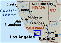
WIDE AREA MAP
|
|
|||||||||||||||||||||||||||||||||||||||||||||||||||||||||||||||||||||||||
|
|||||||||||||||||||||||||||||||||||||||||||||||||||||||||||||||||||||||||
Home | Subject Property Descriptions |
City
of Victorville | Photos | Ralph's
Interior Photos
| Income & Expenses
Parcel Map |
Floor Plan | Site Plan | Alta
Survey | Map & Contact | Printable
Reports
| Request Brochure | Parking
Layout
Send E-Mail
Disclaimer: The information contained herein is subject to errors, omissions, changes in terms and conditions, prior sale, and/or withdrawal from market, all without notice. All information is derived from sources deemed reliable, however, no warranties are either expressed or implied. Prospective purchasers should rely on their own verification of the facts before committing themselves financially or otherwise.


